 The family split up this time to complete our tenth (and final) hikes of the Cuyahoga Challenge (pdf). This entry tells of the boys' trip, starting at Boston Store and heading south on the Buckeye Trail to Pine Lane, then west to Peninsula (still on the Buckeye Trail), then turning north on the Tow Path Trail back to Boston Store.
We've covered the Buckeye Trail segment of this hike to Pine Lane multiple times, with Boy Scouts and fully-laden backpacks, in the fall with little ones and at least once in the snow.
We've even hiked the Pine Lane to Peninsula once (in thigh-deep snow).
So what was left to do but hike the whole thing?
The Cuyahoga Challenge listed this as a loop at around 8.0 miles. Here are our official statistics:
7.26 miles
4.4 mph maximum
3.0 mph moving average
1.9 mph overall average
2 hours, 26 minutes moving time
1 hour, 23 minutes stopped
 What does this all mean? When we were moving, we moved. And we took a lot of look-around breaks.
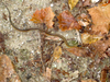
We didn't move so fast that we didn't see cool stuff. Here's a tiny fungus growing on a log.
We over-packed and over-planned. We even over-communicated with the NPS folks at Boston Store. Seeing as we'd be out for four or five hours, we thought we'd leave them a nice note telling them who we are, where we were going, what we were carrying, our experience level, cell-phone number and when we'd be back. They seemed to appreciate this when we returned to the trailhead, but I couldn't help but wonder if this would only incite some worry.
Personally, I think this will be the last time I hike this section for a while. It was a busy, busy trail (runners, walkers and hikers) and the Tow Path was a virtual highway of bikes, runners, walkers and dogs. I think I need a road less traveled for my next one.
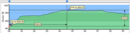 The trail starts out flat, but quickly gets steep as it veers off to the east under Interstate 271 and away from the Tow Path Trail. This initial hill rises 242 vertical feet over the first 400 horizontal feet, somewhat unusual for this part of Ohio and it makes for a fun hike. This quick rise also gets the hiker off the Cuyahoga flood plain and into beeches, maples, oaks and sassafras.
Once over this ridge, the trail parallels Boston Mills Road, nearing the Ohio Turnpike (I80) at one point for a dramatic overlook, then nearing and then crossing Boston Mills Road.
The trail stays away from Boston Mills Road for a bit, wandering around a pine wood, then winding among some old home foundations before returning to the road and using it to cross I80 over to the south and another old pine tree farm.
The rows of old pine trees look majestic, almost cathedral and this is a good place to take a break. With the Valley Bridle Trail coming in from the west and crossing here, a loop can be made (on the VBT) back to Boston Store or the VBT can be used as a speed course directly to Pine Lane Trailhead (and Route 303). Choose the longer road through the rows of pine trees, keeping your feet aware of their "trippy" roots (my daughter's contribution to our lexicon).
At the southern end of these pine trees, another trail can be found that reportedly heads to the Hudson system of trails. Stay on the Blue Blazes and meander the ridges to the old Akron-Peninsula road (now abandoned). Also called North Locust, I suppose it's possible to follow this west into Peninsula and the train station.
The trail follows this road east a bit, then south into the Boston Run valley. From crossing the AP road to this valley, you'll hike three-quarters of a mile and drop a good 150 feet to this creek.
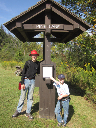
Strangely enough, it's another three-quarters of a mile to Pine Lane Trailhead and another 150 feet up to that point.
 The trail to Peninsula follows Pine Land Road, an old, steep brick lane that drops another 150 feet to the town level. Take the sidewalks on the north side of the street and keep your eye open for the Blue Blazes!
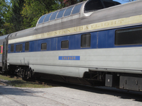
If the train is running, you may get stopped by the Cuyahoga Valley Scenic Railroad. If you're too tired, a few dollars might get you back to near Boston Store.
Otherwise, cross the tracks, head into the parking lot and stay to the south and west. You'll see signs for the Tow Path Trail and Boston Store (but no further Blue Blazes). Head north and stay to the right! This can be an extremely busy thoroughfare!
 Make sure you stop from time to time to understand what you're walking along, on and by.
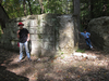
The Cuyahoga is to your west (left) and the canal is to your right (east). You're on the tow path where the mules and horses would tow the canal boats north to Lake Erie or south to the Ohio. The sandstone walls of the locks all have stories, so stop to read the explanations from time to time.
 The path also passes through some fairly wild land: a couple saw a coyote the day we were passing through.
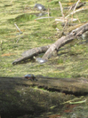
We got a closeup view of a garter snake and a long-range view of some turtles sunning themselves.
The Tow Path Trail is fairly flat, so enjoy your walk back to Boston Store.
Two more things: when you get back to Boston Store, make certain you stop at the museum and get a better understanding of what a canal boat looked like and how the canal system and the locks worked. You've seen them up-close now, so you'll have a greater appreciation for what's in the museum.
And stop at Trail Mix (north side of Boston Mills Road) for some ice cream.
The Boston Store to Pine Lane Trails starts at the Boston Store trailhead (pdf) in the Cuyahoga Valley National Park. It is considered a moderate to difficult trail. The Tow Path Trail back to Boston Store is considered easy.
