The Buckeye Trail heads south from Boston Store using the Towpath Trail (map here and other hiking descriptions here). Just south of the I271 bridge it heads east (left) up the valley and into the woods. This ascent may be the steepest of the trail to Peninsula. Once on the top of the ridge, the trail stays there, angling toward Boston Mills road and eventually crossing it, only to rejoin it further on as a way to get over I80.
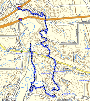
This portion of the trail is quite beautiful but never without the auditory reminder that one is so close to two major highways. From time to time there are quarried stones along the trail, similar to the blocks used in the canal locks a few hundred feet down and some miles away. (No doubt they are different but they do seem out of place on the trail.)
South of I80 the trail returns to the west side of Boston Mills road and enters a pine grove of parallel pines. This is the second of these white pine groves and not the last!
Here also is where the bridle trail crosses the Buckeye Trail and heads separately (and more directly) to Pine Lane Trailhead.
The trail leaves the pine grove for more deciduous limbs of oak, beech, maple, sassafras, tulip and the occasional cottonwood. Crossing a now-abandoned portion of the Akron-Peninsula Road, one is reminded of just how close civilization is before entering the woods again. The trail then begins a staircase descent into a valley where it follows a creek for a short bit. This stepping-stone water crossing is quite simple (although not without risk of damp socks) and on the other side of the creek is another rise back up to nearly the same elevation as before.
View Boston Store to Pine Lane Trailhead in a larger map
The trail then takes a fairly straight beeline south and passes through another pine grove before emerging at the Pine Lane Trailhead.
From Boston Store to Pine Lane Trailhead I measured 3.8 miles by GPS. It's listed as 4.2 in some books. I've hiked this portion once with a full backpack and a patrol of Boy Scouts and again as a family hike with children ranging from 3 to 13. (The three year-old got a back-ride for approximately half the trip.) It's pretty easy to average 1.6 mph under either of these conditions.
There's a small parking lot at Pine Lane Trailhead, making it easy to leave a car here and one at Boston Store.
From Pine Lane Trailhead, one can stay on the Buckeye Trail and head west on an abandoned road for approximately .7 miles to Peninsula. In Peninsula there is more parking, restaurants and access to the Towpath Trail (approximately 2 miles north to Boston Store for a loop) and further south on the Buckeye Trail.
For more details on the trails south of Route 303 shown on this map, refer to this posting of our Scout hike continuing on through Camp Butler and Camp Manatoc.
