« October 2009 | Main | December 2009 »

November 2009 Archives

November 9, 2009

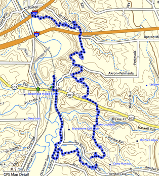
The Route: Boston Store to Peninsula (via Manatoc)

The Buckeye Trail heads south from Boston Store using the Towpath Trail (map here and other hiking descriptions here). Just south of the I271 bridge it heads east (left) up the valley and into the woods. This ascent may be the steepest of the trail to Peninsula. Once on the top of the ridge, the trail stays there, angling toward Boston Mills road and eventually crossing it, only to rejoin it further on as a way to get over I80. Boston Store to Peninsula via Manatoc
This portion of the trail is quite beautiful but never without the auditory reminder that one is so close to two major highways. From time to time there are quarried stones along the trail, similar to the blocks used in the canal locks a few hundred feet down and some miles away. (No doubt they are different but they do seem out of place on the trail.)

South of I80 the trail returns to the west side of Boston Mills road and enters a pine grove of parallel pines. This is the second of these white pine groves and not the last!

Here also is where the bridle trail crosses the Buckeye Trail and heads separately (and more directly) to Pine Lane Trailhead.

The trail leaves the pine grove for more deciduous limbs of oak, beech, maple, sassafras, tulip and the occasional cottonwood. Crossing a now-abandoned portion of the Akron-Peninsula Road, one is reminded of just how close civilization is before entering the woods again. The trail then begins a staircase descent into a valley where it follows a creek for a short bit. This stepping-stone water crossing is quite simple (although not without risk of damp socks) and on the other side of the creek is another rise back up to nearly the same elevation as before.


View Boston Store to Pine Lane Trailhead in a larger map

The trail then takes a fairly straight beeline south and passes through another pine grove before emerging at the Pine Lane Trailhead.

From Boston Store to Pine Lane Trailhead I measured 3.8 miles by GPS. It's listed as 4.2 in some books. I've hiked this portion once with a full backpack and a patrol of Boy Scouts and again as a family hike with children ranging from 3 to 13. (The three year-old got a back-ride for approximately half the trip.) It's pretty easy to average 1.6 mph under either of these conditions.

There's a small parking lot at Pine Lane Trailhead, making it easy to leave a car here and one at Boston Store.

From Pine Lane Trailhead, one can stay on the Buckeye Trail and head west on an abandoned road for approximately .7 miles to Peninsula. In Peninsula there is more parking, restaurants and access to the Towpath Trail (approximately 2 miles north to Boston Store for a loop) and further south on the Buckeye Trail.

For more details on the trails south of Route 303 shown on this map, refer to this posting of our Scout hike continuing on through Camp Butler and Camp Manatoc.

November 11, 2009

Fall Hike in Bedford Reservation

Note: I'm a Tiger Leader with Cleveland Heights' Pack 4 and occasionally blog on their site. This is a cross post from their latest adventure in Bedford Reservation.

Yesterday (November 7th, 2009) was Pack 4's Fall Hike in Bedford Reservation. We chose to hike a portion of the Buckeye Trail starting at Bridal Veil Falls. Here's a good map of the trails. If you're going to print it to take with you, print it in color! The Buckeye Trail and the Bridle Path join and separate and the path is quite confusing at times. Follow the Blue Blazes!

We started at Bridal Veil Falls (point 3 on this map) and hiked about a mile west to the Tinkers Creek Gorge Scenic Overlook (point 2 on this map).

Certainly the leaves were past peak and even so, it was a beautiful hike. The weather was perfect! I'm not sure how we get such wonderful weather on our outings, but the temperature was warm enough (in November!) for short sleeves.

The Bears made some trail food for the hike (achievement 9e: GORP, without the Peanuts and adding Cheerios and M&Ms), the Tigers took a hike to achieve 5G and the Webelos worked toward their Outdoorsman badge.

The picture is looking upstream from the footbridge at Bridal Veil Falls. The whole afternoon was just full of this wonderful light. The sun is low enough that while the treetops were always lit, the hollows and valleys were largely in shadow. The contrasts were just stunning.

Pack 4! — Do your Best!

November 15, 2009

Geocaching in Macedonia's Longwood Park


  curlyshavings couldn't find Knights Treasure (Traditional Cache)     
 
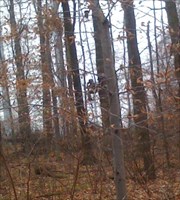
We were about 100 feet from the cache when sirIan points at this guy up in the tree. He waved, so we know he saw us. The GPSr was pointing us toward him and we called off the search. First time I've ever bumped into a hunter in the woods while looking for a geocache. OK, we didn't see a gun or a bow and arrow, but what else would he be doing up in the tree in full camouflage?


Camo guy up in a tree


curlyshavings found ZZZZZZZZZ (Traditional Cache)     


sirIan
claims the find. theLittleOne dragged it out and I signed it for all.
Thanks for the great hike in the woods. The leaves created a blanket
over the mud deep enough not to allow too much sinking.
Geocaching

Follow the Blue Blazes!

Three by the Blaze On one of the last nice days of the year, the whole crew took off from Boston Store to Peninsula on the Buckeye Trail. The route can be found here—it's a duplicate of the one I led the Troop on a few weeks earlier. Only this time the weather was almost too warm!

This first picture is of the smaller ones on the crew right after the first steep climb out of the valley. You can see they're all still smiling and full of energy.

The youngest chirped in my ear nearly the whole way. At one point when we went deep into one of the pine lane sections of the trail, she told me that "it's really dark in the woods, daddy". We definitely had longer shadows than in the summertime.

You can see the deep leaves that we had to navigate. It didn't really make it that much more difficult. Occasionally we'd miss a tree root and stub our toes.

The trail is very well marked; there's really no chance of getting lost.

We learned that only Mom likes walking sticks. The two staves that the oldest brought along got left behind near Boston Mills road at one point (to be retrieved later that evening).

Pine Lane TrailheadAnd this picture is everyone at the end of the trail. They look a bit less energetic, but they're still smiling!

November 23, 2009

Cuyahoga County Bicentennial Barn

The Cuyahoga County Bicentennial Barn is in the middle of a Cleveland suburb. Cuyahoga County Bicentennial Barn

My youngest son and I drove out here this morning to "capture it". He says he doesn't want to visit each and every one in Ohio (there are 88 counties), but we'll get the ones that don't require too much travel out of our way.

We drove about fifty miles round-trip for this one and coupled it with a few errands in downtown Cleveland.

In the process, the boy is learning more about maps, how to read and orient them and when to sing out that a turn is coming up.

If you decide to visit, turn off W 130th onto Wengatz Drive, however, the side nearest the barn is no parking so continue to the end of Wengatz, do a u-turn and come back toward W 130th.

Resources

We're using a few things as resources. Christina Wilkinson's Bicentennial Barns of Ohio is what started this whole quest and has many pictures, directions and some history of each edifice. Mike's Ohio Bicentennial Barns website on the subject also provides directions and longitude and latitude for each. Of course, no road trip would be complete without using Google Maps for some part of the journey.

November 24, 2009

Summit County Bicentennial Barn

The Summit County Bicentennial Barn is located in an area that appears to be converting from farmland to more developed property. Summit County Bicentennial Barn

We were already planning a visit to the Cuyahoga Valley National Park to pick up our Thanksgiving turkey at Goatfeathers Point Farm and do a bit of shopping at the Appalachian Outfitters Peninsula store, so this was fairly "close" for us (approximately sixty miles, round-trip).

The painted side of the barn is visible from Route 8 and I suspect that stopping for pictures isn't wise. We stopped on Hudson Drive and I walked around the barn to the west for my picture.

No doubt I was trespassing.

Resources

We're using a few things as resources. Christina Wilkinson's Bicentennial Barns of Ohio is what started this whole quest and has many pictures, directions and some history of each edifice. Mike's Ohio Bicentennial Barns website on the subject also provides directions and longitude and latitude for each. Of course, no road trip would be complete without using Google Maps for some part of the journey.

November 25, 2009

Lake County Bicentennial Barn

The Lake County Bicentennial Barn is in the middle of homes and businesses not very far from Lake Erie. Lake County Bicentennial Barn

We planned this barn around a trip to Willoughby Brewing Company for lunch with Mr. Lee who lives in the area and accompanied us to the barn. The round trip total is approximately fifty miles.

The painted side of the barn is visible from Munson Road but I don't recommend stopping there. A small church is just to the west of the barn and we took advantage of their ample parking and midweek emptiness for a few minutes. While Munson is busy, there is a bike lane that give pedestrians just that added bit of space.

Afterward, we took the long way back to Mr. Lee's house and visited a very pretty yellow barn on Baldwin Road, just north of the Episcopal Church there.

Resources

We're using a few things as resources. Christina Wilkinson's Bicentennial Barns of Ohio is what started this whole quest and has many pictures, directions and some history of each edifice. Mike's Ohio Bicentennial Barns website on the subject also provides directions and longitude and latitude for each. Of course, no road trip would be complete without using Google Maps for some part of the journey.

November 22, 2009

Ohio Bicentennial Barns

In 2003, Ohio celebrated its 200th anniversary as a state. To observe the event, a barn was chosen from each county to have an anniversary logo painted on a prominent side. All the barns were painted by barn artist Scott Hagan.

All the barns have already been cataloged at the Ohio Barns web site.

We will be adding markers to this map as we plan out our visits to them.

If you're viewing this map and it isn't showing barns, please view this posting by itself.

November 26, 2009

Geocaching before the turkey

The turkey wasn't ready so we decided to go caching. Took sirIan and the littleOne with me. Celebrated the find by a walk around the lower Shaker Lake. Saw a blue heron and a million leaves. Blue Heron on Lower Shaker Lake

The littleOne likes to collect leaves, so our celebratory walk around Lower Shaker Lake took much longer than it would have ordinarily. Additionally, we probably enjoyed it more as well! There are just so many leaves and so little time. So many leaves, so little time.

Buckeye Trail Segments Hiked

Here's a map showing the segments of the Buckeye Trail that I have hiked.


View Buckeye Trail Segments Hiked in a larger map

Everett to Botzum
9/20/2008, whole family
Boston Store to Pine Lane Trailhead
10/17/2009, with Troop 403
11/8/2009, whole family
1/1/2010, JDG, JRG, EMG, BIG, JMG, DRG
9/18/2010, JDG, JRD, BIG and continued to Tow Path Trail and back to Boston Store
Pine Lane Trailhead to Tow Path Trail (Peninsula)
2/14/2010, JDG, BIG, EMG
9/18/2010, JDG, JRD, BIG
Headlands Beach State Park
10/25/2009, whole family
Bedford Reservation, Bridal Veil to Gorge Overlook
11/7/2009, Pack 4
Bedford Metroparks, Northfield to Richmond
10/30/2009, whole family

About November 2009

This page contains all entries posted to CurlyShavings in November 2009. They are listed from oldest to newest.

October 2009 is the previous archive.

December 2009 is the next archive.

Many more can be found on the main index page or by looking through the archives.

Creative Commons License
This weblog is licensed under a Creative Commons License.